The White Stuff: Why Clouds Appear White and Sometimes Gray or Dark
Clouds are perhaps one of the most intriguing forms in the nature because they are the suspended matters which are in the form of liquid droplets or ice crystals in the Earth’s atmosphere. They are very crucial in earth’s weather system; in meteorology for climate forecasting and in daily observations for short term changes in the weather.
How Clouds are Formed?
Cloud Formation:
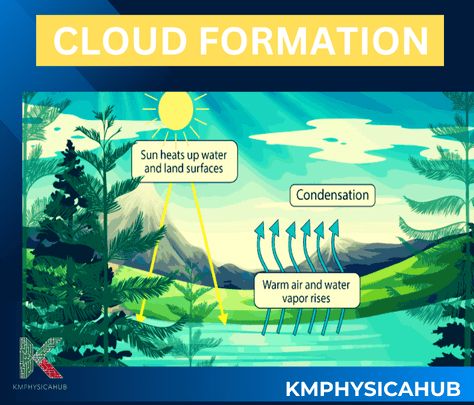
Clouds are visible mass of condensed water droplets or ice crystals in the atmosphere of earth. These particles combine to form clouds.

Steps for formation of clouds:
- Evaporation:
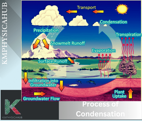
It all begins with evaporation. Liquid water from oceans, lakes, rivers, and even wet towels or bowls changes into an invisible gas called water vapor. Heat from the Sun or other water molecules provides the energy needed for this transformation. Water molecules escape from liquid water, carrying heat with them into the atmosphere.
- Saturation and Cooling:
Water vapor is one of the components of the air and it dissolved in the air in a limited quantity depending on temperature pressure etc. When a volume of air is fully saturated i.e., contains all the amount of water vapor possible, then it is set for cloud formation. The air which is saturated in the lower troposphere rises, and cools, due to pressure decrease, and comes into contact with cooler segments in the troposphere.
- Condensation:
Nowadays, tiny particles floating in the air such as dust, salt crystals or ash offer surfaces on which water vapors can condense. There is a change of phase and the water vapor condenses on these particles forming liquid droplets or ice crystals. A large accumulation of droplets or crystals forms a cloud.

Types of Clouds
Clouds exhibit a range of forms and dimensions. For instance:
Cumulus clouds are characterized by their fluffiness and typically signify pleasant weather.
Stratus clouds form in layers and can bring overcast skies.
Cirrus clouds are thin and are found at a high altitude of the sky; they are made up of ice crystals.
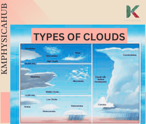
High Clouds (16,500-45,000 feet):
- Cirrus Clouds are fluffy and thin and are composed mainly of ice crystals. They look very thin and precede alteration of the weather.
- Cirrostratus clouds are stratus shaped thin clouds which appear to be white layers over the sky. Find out when the sun or the moon has halos around—this is usually a sign that it is going to rain or snow in the next 24 hours.
- Cirrocumulus clouds are thin, patchy sheets with ripples, or small grains in appearance. In the tropic zone they indicate the approach of a hurricane calamity.
Mid-Level Clouds (6,500-23,000 feet):
- Altocumulus Clouds are almost in patches appearing as white or gray layers with piling peaks resembling fluffy waves. They’re made of liquid water and rarely produce rain.
- Altostratus Clouds are gray or blue-gray, These come in layers extending halfway across the sky. Expect continuous rain or snow.
Low Clouds (less than 6,500 feet):
- Cumulus clouds appear as puffy, white cotton balls. They vary in size and shape and often appear during fair weather.
- Stratus Clouds are thin, white sheets that cover the sky. They don’t usually bring much rain or snow.
- Cumulonimbus Clouds tower on hot days, resembling huge mountains. Watch out for rain, hail, and tornadoes!
- Stratocumulus Clouds are patchy gray or white clouds with a honeycomb-like appearance.
Why do Clouds appear White?
Clouds appear white against the blue sky due to a fascinating interplay of light and water droplets.
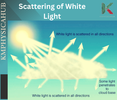
Clouds appear white while sky appears blue because of the different sizes of the particles that scatter sunlight. The small molecules in the atmosphere scatter blue light more than other colors. Clouds are formed by larger water droplets that scatter all colors almost equally, meaning that the sunlight remains white. This is why clouds look white against the blue sky.
Explanation:
- Sunlight and White Light:
The Earth’s natural source of light is the Sun, which emits white light. White light combines all colors in the visible spectrum. Each color represents electromagnetic waves of varying lengths. With increasing wavelength, colors range from violet to indigo, blue, green, yellow, orange-red, deep red. Hence, visible light is only a portion of the total electromagnetic range of waves.
- Rayleigh Scattering:
It is actually due to a process known as Rayleigh scattering that the sky appears blue in color. The particles of the atmospheric gases such as atoms as well as molecules are minute in size as compared with the length of the sunlight spectrum.
When sunlight enters the atmosphere, collisions cause shorter violet light waves to scatter first (though they’re not readily seen). Next, indigo light waves scatter, visible from high altitudes (like from jet airplanes). Finally, blue light waves scatter about four times more than red light waves. The volume of scattering by blue, violet, and indigo dominates, making us perceive the sky as blue.
- Why Clouds Are White:
Unlike Rayleigh scattering when light waves are larger than the gaseous particles, clouds are composed of water droplets. These droplets have a size that is equal to the wavelength of sunlight or about one micrometer in diameter.
When sunlight passes through clouds, no colors disperse more effectively. As a result, the light remains white. We see clouds as white against the blue sky because of this scattering effect.

Why do Clouds sometimes appear Gray or Dark?
- Gray Rain Clouds:
Cumulonimbus clouds which are rain clouds look gray or dark due to their depth in the sky. Clouds become denser, as the mass of water droplets and ice crystals in a cloud increases with their number. The effect is that thicker clouds reduce the number of lights that can penetrate through the cloud layer. And yet, the bottom of the rain clouds has not enough light to scatter, so it looks gray from the ground.
- Water Droplet Size:
Just before rain or snowfall, water droplets grow larger and become more efficient at absorbing light rather than scattering it. This effect intensifies the gray appearance of rain clouds.
Therefore, cloud thickness and water content significantly influence cloud color. So next time that you observe dark gray clouds, then you will understand that they contain water.

Fun Facts about Clouds
Variety in Classification: According to the shape of clouds and the height they are set at, there are several forms of clouds. The main classification is cirriform, which is thin and high; cumuliform, which is lofty and mid-altitude; and stratus form which is flat, low altitude, and layered.
Cloud Seeding: Cloud seeding is a technique that humans have tried to use with an aim of altering weather patterns. An example is putting substances such as silver iodide into the cloud; this enhances precipitation. This practice has been used in agriculture and water management successfully.
Noctilucent Clouds: These are the clouds that are found in the mesosphere and it is the highest clouds in the earth’ atmosphere. They appear during dusk and this is when the sun shines at the back and below the horizon which makes it to have a beautiful glowing nature.
Role in Climate: Clouds are a very integral part of the Earth’s climate system. They can have a dual role and can both prevent the sunlight from reaching the surface and therefore, cooling it down or trap heat in the atmosphere, thus, warming it up. Understanding this dual impact is crucial for climate studies.
Pyrocumulus Clouds: These clouds develop above hot surface regions such as fire scenes or hot volcanic zones. The hot air, drawn in by convection, carries up with it ash and moisture that condense into clouds.
Conclusion:
This is due to the fact that cloud are scattering all the wavelength of light which makes them white and their grayish color comes from the structure of the cloud and its thickness. However, let us look at clouds as more than mere objects of beauty; they are objects of interest due to the number of types, phenomena of interest, influence on the environment. Knowledge of different types of clouds and their features can be crucial for weather forecast and climate research.
The cloud formations are high clouds, middle clouds, low clouds, and vertically developed clouds and using these classifications we can understand the role of cloud in atmospheric system of the earth. Studying them enables better understanding of meteorological processes and interconnections of the climatic system on the Earth. Whether one looks at them as beauties or as scientific wonders, clouds remain among the still interesting parts of the natural environment.
FAQS
Q1: Why are clouds white?
A: The white appearance of clouds comes from the fact that all wavelengths are actually scattered. Clouds look white because water droplets and ice crystals contained within the clouds are large enough to allow the light to reflect across the visible spectrum. If the clouds thicken, it may be observed that they are grey or even black since much of the light is blocked.
Q2: How do clouds form?
A: When warm and moist air is forced to rise, then we have clouds. As it moves up, it cools and expands evaporating into tiny droplets or ice crusters around dust particles in the air, a process known as nucleation.
Q3: Can clouds affect the climate?
A: Yes, clouds are one of the factors that influence climate to a greater extent. They can reflect sunlight and reduce heat emission to cool down the Earth’s surface and trap heat to warm it up. Therefore, the influence of clouds on the climate of the Earth is one area of meteorology and climate science that is still an active research topic.
Q4: Why do some clouds bring rain while others do not?
A: Rain develops when tiny water droplets in clouds combine and get bigger until they can reach the surface of the earth. Some types of cloud such as nimbostratus and cumulonimbus have the power to lift small drop size up high enough to combine with other to form precipitation while other cloud like cirrus and stratus or likely to produce fine droplets or in some cases, no precipitation at all.
Q5: Why do clouds look different in different parts of the world?
A: The accumulation of clouds depends on place, climate, and current or forecast weather conditions. For instance, cumuliform clouds develop in the warm countries mainly because of intensive surface heating, whereas stratiform clouds form in temperate and polar countries.
